In the Footsteps of Frederick the Great
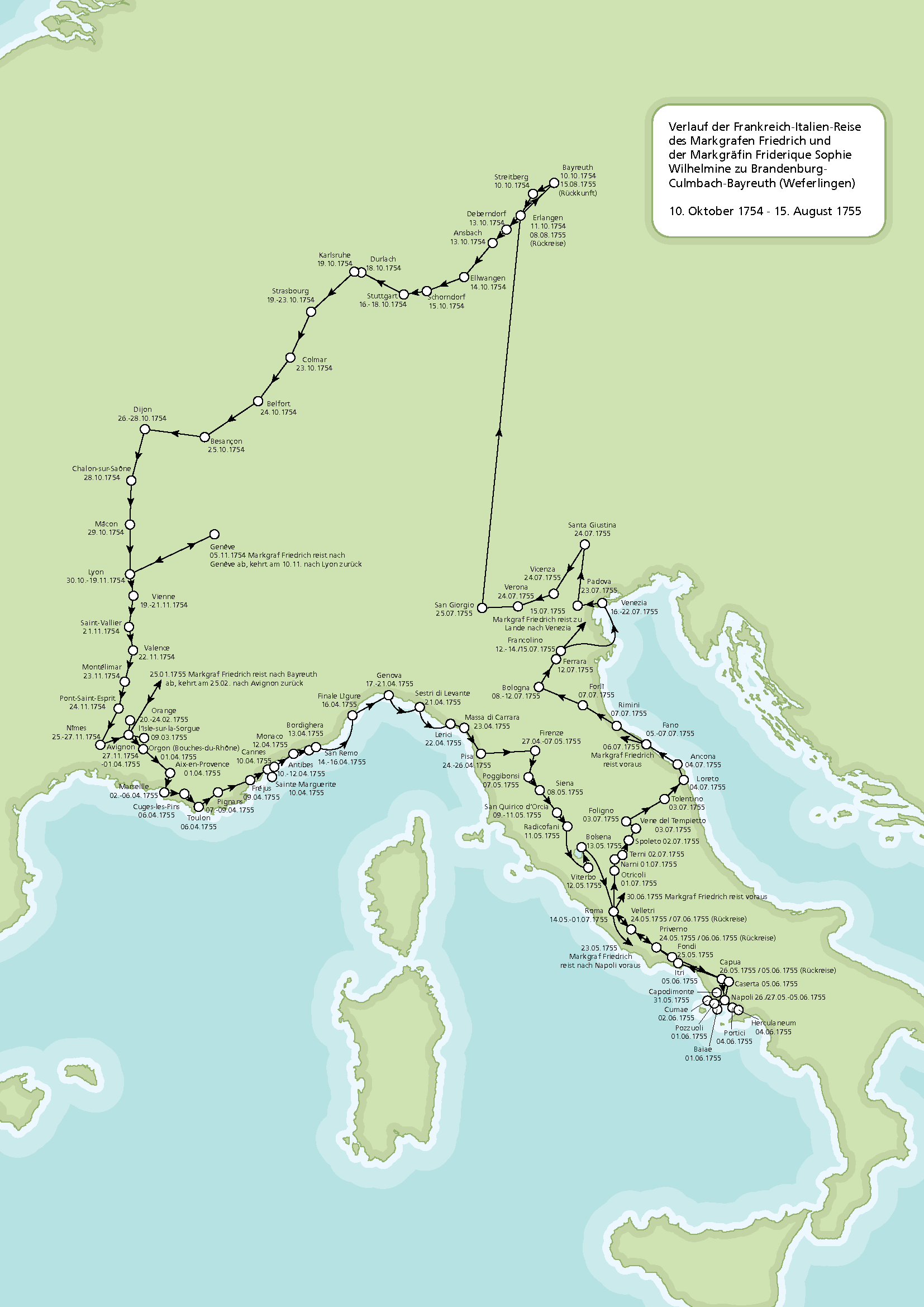
Jan. 20th, 2020 12:57 pmSo remember when ![[personal profile]](https://www.dreamwidth.org/img/silk/identity/user.png) selenak shared with us a map of Wilhelmine's itinerary on her trip to France and Italy? [Original write-up here, revised edition ported to
selenak shared with us a map of Wilhelmine's itinerary on her trip to France and Italy? [Original write-up here, revised edition ported to ![[community profile]](https://www.dreamwidth.org/img/silk/identity/community.png) rheinsberg here.] And I said I wanted one for Fritz, but like every month of his life?
rheinsberg here.] And I said I wanted one for Fritz, but like every month of his life?
Well, it occurred to me that you could put together a pretty good approximation from his correspondence. It's obviously going to be very light on the early years, especially pre-1730. You'd have to do that manually. But after 1740, we have reams and reams of correspondence for him, and it all comes with locations.
So I, uh, wrote some code. Like I do.
Then it turned out that code is easy, data wrangling is hard. (This is the mantra of data scientists everywhere.) In our case, data wrangling = converting the 18th century German names of cities into 21st century German, Polish, and Czech names with standardized spellings, and getting the latitude and longitude manually for the really small and obscure ones. Ahahahaaaa.
I ended up manually googling ~500 names that I couldn't automatically match to any modern place names. Some of them were pretty damn hard to track down. In a few cases, I had to go read the letter in question to figure out where the fuck he was, or his memoirs. Fortunately, in the one case where I absolutely could not find a modern equivalent even after reading the letter and would have been stumped, he conveniently described his location in the letter as "near this city, on this river, and just on the opposite side of this other river from this other city," which meant I could get fairly precise coordinates even without being able to match up names. Thanks, Fritz! His memoirs were actually pretty useful too in giving geographical descriptions.
The data before 1740 is incredibly sparse, so I started with his accession.
Then it turned out that there was way too much data for 1740 onward to fit comfortably onto one map, so I made it into a video and put it on Youtube.
The approximate movements of Frederick the Great beginning in 1740, as extracted from his correspondence. No audio.
Corrections and supplements welcome. Raw data and code provided on request, free of charge and free to use as you wish.
Caveats:
1. The reason the map stops in late 1781 is that his published political correspondence only goes up to 1783, and the digitized parts only to early 1782, and most of his personal correspondents were dead by that point, so there's very little data in an easily extractable form after 1782. We know, for example, that until 1785 he continued to attend the autumn maneuvers in Silesia, but none of that is reflected in his correspondence. Before 1740, his correspondence is only slightly less sparse compared to his known movements, so I have elected to omit that as well.
2. Some other known movements are not reflected in his correspondence, such as the trip to Bayreuth and Strasbourg in 1740.
3. Some of the material listed in his political correspondence was written by officials who were not in the same place that he was. This especially accounts for some spurious instances of Berlin in the data set. I've attempted to identify and remove the most obvious cases, but with tens of thousands of letters, I didn't go through each one by hand, and so I no doubt missed some.
4. I made some educated guesses when I was unable to link an 18th century place name to a modern-day place name with certainty.
5. It appears to be the case that multiple letters written on the same day in the same location might have either one of several nearby obscure villages or a farther away major populated area, with this possibly but not necessarily representing actual physical movement. I've consolidated many of these cases.
As a result, some actual movements back and forth have inadvertently been pruned out. There are probably also some cases where I failed to consolidate where I should have.
6. When consolidating small villages and larger towns or cities, I preferred smaller villages, because they were more likely to be precise.
7. I deliberately consolidated all the movements back and forth between Berlin and Potsdam, because that accounts for 50% of all the action and gets rather tedious to watch.
Credits:
For Frederick's correspondence, with locations, I used the University of Trier website, with personal and political correspondence: http://friedrich.uni-trier.de/
For the modern-day borders of Europe, I used a shapefile from Natural Earth: naturalearthdata.com
For the latitude and longitude of the place names where there was a one-to-one mapping of the 18th century spelling and the modern-day location, I used a shapefile from MapCruzin: mapcruzin.com
For the latitude and longitude for 18th century place names for which I had to manually find a modern-day equivalent, I used Google Maps: https://maps.google.com/
I used R to turn the names, dates, and coordinates into image files, and ImageMagick to turn the image files into a video file.